UNC PhD candidate Francisco Laso alongside UNC researcher Javier Arce-Nazario and other partners from Universidad San Francisco de Quito have published the first high-resolution land cover maps of the humid highlands in the Galapagos. The humid highlands include the region’s agricultural zones, represent crucial habitat for endemic species, and are the main battleground against invasive species. This open-access dataset has applications in the context of both conservation and agriculture.
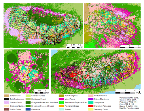 The surface of the Galapagos islands’ non-protected humid highlands reflects the region’s history of agricultural expansion and subsequent abandonment. The agricultural areas are currently covered by a mosaic of invasive vegetation (≈28%), pastures (≈22%), native vegetation (≈19%), annual and perennial crops (≈18%), as well as a mixture of these categories (≈12%). This baseline dataset allows conservation organizations to optimize resources for the control of invasive plant species in the present and track the spread of invasive plants in the future. This dataset is also useful for the agricultural sector’s sustainable management by allowing decision-makers to calculate the labor and funds necessary to maintain functioning crop and livestock farms active and reactivating abandoned agricultural lands. Lastly, information on land cover is fundamental for scientists to design conservation interventions that protect or expand the suitable habitat of endemic species. This includes the emblematic Galapagos Tortoises, which use the humid highlands for foraging and mating, as well as land birds that use these areas for nesting. This map of the Galapagos’ non-protected highlands is compatible with existing land cover datasets of the Galapagos National Park (Rivas et. al., 2018), giving us for the first time a complete view of the land cover of the Galapagos Islands in high-resolution. The entire dataset has been published in the Open Access journal Remote Sensing so everyone can access it for free here.
Laso, F. J., Benítez, F. L., Rivas-Torres, G., Sampedro, C., & Arce-Nazario, J. (2020). Land Cover Classification of Complex Agroecosystems in the Non-Protected Highlands of the Galapagos Islands. Remote Sensing, 12(65), 1–39. https://doi.org/10.3390/rs12010065